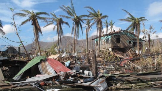
Near-record Atlantic Ocean temperatures and the development of La Niña conditions in the Pacific will likely lead to above-normal hurricane activity in the Atlantic basin this year, NOAA said on Friday.
—
The Atlantic hurricane season will likely be “above-normal” this year, owing to near-record ocean heat and La Niña conditions, the US weather agency has warned.
The National Oceanic and Atmospheric Administration (NOAA) predicts a range of 17 to 25 named storms (wind speed of 39 mph or 65 km/h) this year, eight to 13 of which are forecast to become hurricanes (wind speed of 74 mph or 119 km/h). Of these, 4 to 7 are forecast to be major hurricanes. The latter can be classified as category 3, 4, or 5 depending on wind speed, with the highest level assigned to storms with winds blowing at a speed of at least 157 mph or 252 km/h. An average year sees 14 named storms.
Hurricanes – also known as typhoons in the northwestern Pacific and cyclones in the Indian Ocean and South Pacific – are a rather common weather phenomenon, though there has been a significant increase in their intensity in recent decades, which scientific observations link to anthropogenic climate change.
These abnormal trends are attributed largely to the increased ocean temperatures – warmer than normal Atlantic waters. Indeed, as ocean surfaces warm, so does the air above it, causing water to be carried up to high altitudes to form clouds, while leaving a low pressure zone beneath causing more air to rush in. As these systems build up, thunderstorms are formed, and if there are no strong winds to slow it down, they can become hurricanes.
This year, a combination of near-record heat in the Atlantic Ocean and the development of La Niña conditions in the Pacific will favor the development of storms and hurricanes in the Atlantic basin, according to NOAA.
La Niña, a phenomenon that typically occurs every 3 to 5 years, is expected to develop between July and September this year. It is associated with the periodic cooling of ocean surface temperatures in the central and east-central equatorial Pacific, weaker Atlantic trade winds and less atmospheric stability, conditions that are conductive to Atlantic hurricane activity.

“Severe weather and emergencies can happen at any moment, which is why individuals and communities need to be prepared today,” said Federal Emergency Management Agency (FEMA) Deputy Administrator Erik A. Hooks. “Already, we are seeing storms move across the country that can bring additional hazards like tornadoes, flooding and hail. Taking a proactive approach to our increasingly challenging climate landscape today can make a difference in how people can recover tomorrow.”
If true, the predictions would make this year the ninth consecutive to see an above-normal hurricane season, according to the World Meteorological Organization (WMO).
According to a paper published last year, the 1971 Saffir-Simpson hurricane wind scale, the most widely recognized risk assessment method for tropical cyclones, which classifies hurricanes into five categories based on their sustained winds, is no longer accurate in measuring the climate change-driven exponential increase in winds.
According to the authors, the fact that the scale is open-ended – meaning that anything beyond 157 mph or 252 km/h is classified as Category 5 and assigned the same level of wind hazard – reflects a flaw in the system, no matter if it is blowing 160 mph (257 km/h), like 2022 Hurricane Ian in the US, or 215 mph (346 km/h), like Mexico’s 2015 Hurricane Patricia. For this reason, they suggested adding a hypothetical new category – Category 6 – to the scale, which would reflect the wind speed that has already been reached in a number of storms that happened in the last decade, including Typhoon Haiyan (2013), Typhoon Meranti (2016), Typhoon Goni (2020), and Typhoon Surigae (2021) in the Western Pacific and Hurricane Patricia (2015) in the Eastern Pacific.
A 2020 analysis of satellite records from 1979 to 2017 found that the likelihood of a storm reaching Category 3 or above, with sustained winds of 185 km/h, increased by 8% per decade. In 2023, the Intergovernmental Panel on Climate Change’s (IPCC) Sixth Assessment Report (AR6) confirmed these observations, arguing that the proportion of Category 3-5 tropical cyclones as well as the frequency of rapid intensification events have likely increased globally over the past four decades. And with our atmosphere and oceans set to continue warming in the coming years as the climate crisis intensifies, there is little doubt that wind speeds will also progressively strengthen.
This story is funded by readers like you
Our non-profit newsroom provides climate coverage free of charge and advertising. Your one-off or monthly donations play a crucial role in supporting our operations, expanding our reach, and maintaining our editorial independence.
About EO | Mission Statement | Impact & Reach | Write for us